
 Svenska
 Español
 English
ПО
- GPRSoft® PRO and Standard
- Versions and modules
- Feature matrix
- Supported file formats
- System requirements
Overview
The user-friendly alternative is here!
GPRSoft™ is the affordable and user friendly solution for displaying, post-processing and interpreting ground penetrating radar data. With an intuitive interface and the shortest possible learning curve it allows you to focus on your work rather than on the tool you are using!
GPRSoft™ has full support for data files from all the major ground penetrating radar manufacturers and we are constantly revising the implemented formats to comply with newer modifications or add ons.

Overview
GPRSoft™ versions and additional modules
The software has been divided into logical complexity levels to deliver the required
processing power depending on the user application demands.
There are users that don't need an entire set of functions in their every day work. For these customers we have prepared a well balanced entry level version of the software. We gave our best at keeping the most useful functions and dismissing the clutter of those that are rarely used in simple post processing. The result of our efforts is the Standard version of the software.
As opposed to simple processing needs, there are users that just need the most processing functions and power possible.
We are constantly improving and adding processing algorithms and functionality that reduces the use of most complex formulas to a press of a button or a simple input dialogue box.
This kind of approach will hopefully reach out to the users without prior geophysical knowledge
and reduce the time spent on processing for the geophysical experts.
To compare these two versions and select the version that suits your needs best please check the complete list of Features (feature matrix)
As a final addition to your interpretation methods there is the 3D module which will allow you to easily view a set of 2D profiles as a 3D grid representation. To build a 3Dproject file you will need a GPRSoft™Pro version.
To compare these two versions and select the version that suits your needs best please check the complete list of Features (feature matrix)
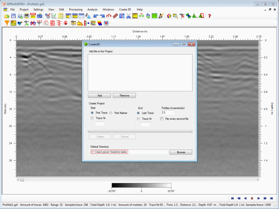
As a final addition to your interpretation methods there is the 3D module which will allow you to easily view a set of 2D profiles as a 3D grid representation. To build a 3Dproject file you will need a GPRSoft™Pro version.
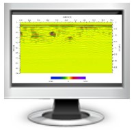
View the data the way you like!
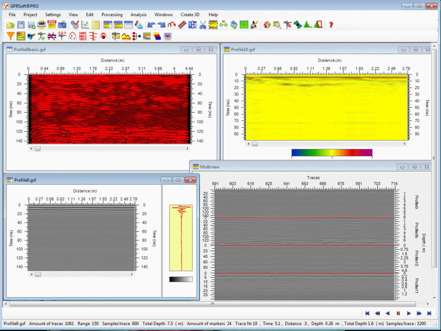
In GPRSoft™ there is a number of ways to show your data. No matter
which view you choose you gain full control over the available scales
and color palettes used for representation of your data. Each opened
file is treated as a separate entity so you can apply different
settings for each window frame in the way that best suites the data.
In addition to, more or less, standard views like wiggle trace, B scan (profile) and A+B scan (profile and trace) we are proud to present a Multiview experience.
This view allows you to view up to four files simultaneously. They will be shown in one window frame and the scrolling will be synced. This allows you to interpret and export reports based on a direct comparison of files with the same baseline or raw and processed data.
Publishing your work and creating reports
GPRSoft is not limited just to flawless data processing. By implementing
internal professional tools for report creation we made it an even more
unique software. When put together, these tools save you from tedious
screen printouts and commenting over some graphic in third party software.
Also it is worth mentioning that the software does not create simple and
low resolution "screen dumps" of the data windows, but recreates a new
export based on the selected preferences.
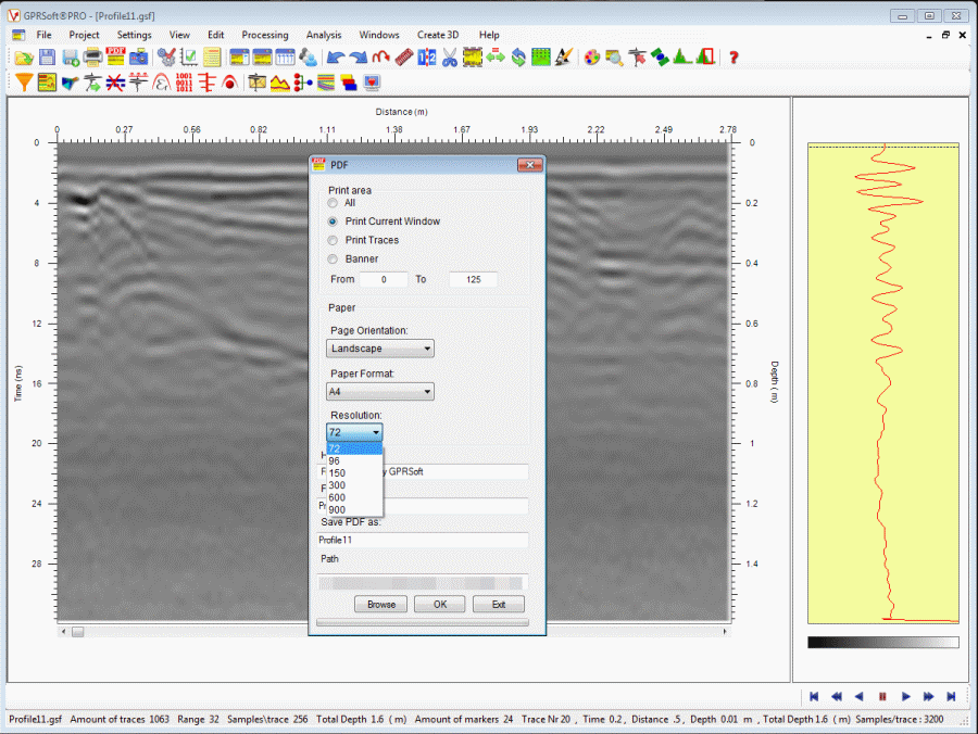
The most used tool is the internal PDF tool, allowing you to print out your processed data in high resolution in the most used format for electronic distribution in general or for creating intermediate reports.
The most used tool is the internal PDF tool, allowing you to print out your processed data in high resolution in the most used format for electronic distribution in general or for creating intermediate reports.
In addition to being able to export directly from the program we
have implemented the tools to comment and annotate your data directly
in the GPRSoft™ environment.
By selecting Object tools or Layers you will be able to put the comments at precisely the spot you wish and can also save your work for future modification or continuation of annotation. The way these publishing tools work is straight forward and gives the user a truly WYSIWYG interface for publishing the work. This means that each comment, line, scale and label will be exported exactly as you see it on screen allowing you to evaluate the final report before you make it.
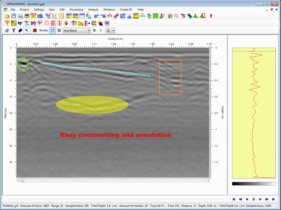
By selecting Object tools or Layers you will be able to put the comments at precisely the spot you wish and can also save your work for future modification or continuation of annotation. The way these publishing tools work is straight forward and gives the user a truly WYSIWYG interface for publishing the work. This means that each comment, line, scale and label will be exported exactly as you see it on screen allowing you to evaluate the final report before you make it.
Many DSP tools at your finger tips
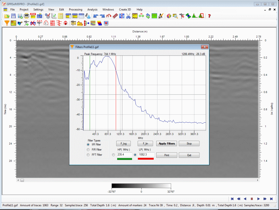
GPRSoft™ has more than a dozen automatic and semiautomatic DSP tools
to help you interpret the ground penetrating data. Different kind of
filters with extremely easy user interface are included, gain functions,
correction functions and many more are available as well.
One of the unique features of GPRSoft software package is that all this DSP tools can be repeated several times in any order you want to obtain the cleanest data possible. At the same time the original data will stay intact unless you explicitly save the changes. That combined with the undo and redo function can give you a degree of freedom not seen before in other similar software packages.
One of the unique features of GPRSoft software package is that all this DSP tools can be repeated several times in any order you want to obtain the cleanest data possible. At the same time the original data will stay intact unless you explicitly save the changes. That combined with the undo and redo function can give you a degree of freedom not seen before in other similar software packages.
Overview
|
Feature |
Standard Edition | PRO Edition |
| Supports: .GSF, .DZT, .RD3, .DT1, .SEGY, .SGY, .DT |

|
|
|
| Save file as: .GSF, .DZT, .RD3 | |
|
|
| Batch saving function |  |
|
|
| Fully customizable print function | |
|
|
| Create fully customizable PDF files | |
|
|
| PDF Generator supports dpi from 72 to 900 | |
|
|
| Creates Banner PDF printouts | |
|
|
| Screen dump of B-Scan as .BMP, .GIF, .PNG, .JPG, .TIF | |
|
|
| Processing Undo/Redo with custom amount of steps | |
|
|
| Data view as B-Scan, B+A-Scan, A-Scan, Wiggle | |
|
|
| Fully customizable horizontal and vertical scales | |
|
|
| Create, Load, Editing of color scales (palettes) | |
|
|
| Fully customizable wiggle view by several parameters | |
|
|
| Selectable vertical and horizontal viewing sections | |
|
|
| Visible grid and signal polarity change | |
|
|
| Skip traces | |
|
|
| Compress data | |
|
|
| Joining two files (files with the same parameters) | |
|
|
| Cut out unwanted data blocks | |
|
|
| Crop wanted data into more manageable file sizes | |
|
|
| Reverse file collection, first trace becomes last | |
|
|
| Zooming function with adjusted scales | |
|
|
| Point info on any part of the displayed window | |
|
|
| FFT analysis of data, partial and complete | |
|
|
| DC removal function | |
|
|
| Filter function, IIR, FIR and FFT (boxcar) | |
|
|
| Background removal, partial or complete | |
|
|
| Dewow function (LP filter based on weighted average) | |
|
|
| Gain function (linear, log, squares, custom) | |
|
|
| Gain function AGC | |
|
|
| Static correction, manual and automatic | |
|
|
| Stack function | |
|
|
| Feature Description | |
|
|
| Velocity analysis tool (hyperbola, slope, migration) | |
|
|
| Local peaks detection and emphasizing tool | |
|
|
| Migration tool | |
|
|
| Macro creation, loading and editing function | |
|
|
| Layer tool (create, load, edit, reports) | |
|
|
| Batch function | |
|
|
| 3D creating and processing tool (3D module required) | |
|
|
| Coordinates module (GPS coordinates and grids) | |
|
|
| Distance normalization | |
|
|
| Envelope function | |
|
|
| Topography correction, internal or external data | |
|
|
| Elevation vertical scales | |
|
|
| Re-sampling, four different modes supported | |
|
Overview
· GSF Ground penetrating radar
from Geoscanners AB, Sweden.
· GOF Ground penetrating radar
from Geoscanners AB, Sweden.
· DT (S&S) Ground penetrating radar
from Sensors & Software Inc., Canada.
· DZT Ground penetrating radar
from Geophysical Survey Systems Inc., USA.
· RD3 Ground penetrating radar
from Malå Geoscience AB, Sweden.
· SEG-Y (Radsys) Ground penetrating radar
from Radar Systems Inc., Latvia.
· SEG-2 (SPRScan) Ground penetrating radar
from ERA Ltd, UK.
· DT1 and Zon Ground penetrating radar
from IDS GeoRadar Division, Italy.
from Geoscanners AB, Sweden.
· GOF Ground penetrating radar
from Geoscanners AB, Sweden.
· DT (S&S) Ground penetrating radar
from Sensors & Software Inc., Canada.
· DZT Ground penetrating radar
from Geophysical Survey Systems Inc., USA.
· RD3 Ground penetrating radar
from Malå Geoscience AB, Sweden.
· SEG-Y (Radsys) Ground penetrating radar
from Radar Systems Inc., Latvia.
· SEG-2 (SPRScan) Ground penetrating radar
from ERA Ltd, UK.
· DT1 and Zon Ground penetrating radar
from IDS GeoRadar Division, Italy.
Overview
- Windows® 2k, XP, Vista or Windows® 7.
- 32-bit or native 64-bit Microsoft® Windows
machines.
- Intel® processor 1 GHz CPU clock,
recommended 2.4 GHz or higher.
- 1024 megabytes (MB) of RAM,
recommended 2048 MB or higher.
- 50 MB free disk space plus enough space
to import the file.
- 256-color video display adapter.
- Screen area: 800x600,
recommended 1024x768 or better.